Mann Shwesettaw Footprints Pagoda
Sacred upper and lower Buddha footprints on the Mann Creek celebrated during the annual dry-season festival.
Magway Region lies in central Myanmar along the Ayeyarwaddy River, known as the petroleum capital, dry zone agriculture, and sacred pilgrimage destinations.
Magway Region is bordered by Sagaing Region to the north, Mandalay Region to the east, Bago Region to the south, and Rakhine and Chin States to the west. It is the largest producer of petroleum, natural gas, sesamum, and groundnut in Myanmar.
Magway is the capital city housing the sacred Mya Tha Lun Pagoda on the riverbank. Other prominent centers include Pakokku, Minbu (famed for its dragon mud volcano), Yenangyaung, and Chauk.
Population
Capital City
Townships
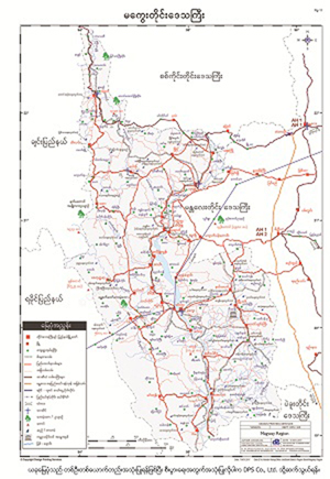
To download the full and complete Magway Region Map:
Pilgrimage sanctuaries and geologic attractions in Magway.
Sacred upper and lower Buddha footprints on the Mann Creek celebrated during the annual dry-season festival.
Geothermal mud bubbling mounds on top of a scenic hill overlooking the Ayeyarwaddy River plains.
Magnificent golden pagoda situated on the high river bluffs of Magway offering sunset panoramas.